It's Time to Explore the River of the Year and the Trail of the
Year
Pittsburgh Post-Gazette
4 February 2017
By John Hayes
Two of Western Pennsylvania’s outdoor treasures are getting
additional recognition in 2017.
In January, the Allegheny River was selected as the state River of
the Year, and the Montour Trail was designated Trail of the Year.
The annual distinctions are intended to elevate public awareness
of the state’s natural resources. On Jan. 9, following a 2016
application process and public online voting, the state Department
of Conservation and Natural Resources announced the winner of the
public’s pick for top river. Seventeen days later on Jan. 26, the
former railroad passage in Allegheny and Washington counties was
given top trail honors.
“Is it coincidental? Well, in a way it is, and in a way it’s not,”
said DCNR Secretary Cindy Adams Dunn. “We didn’t line them up like
that. But when you think about it, Western Pennsylvania has some
of the state’s best natural assets. Its rivers and trails are
always in competition for these distinctions.”
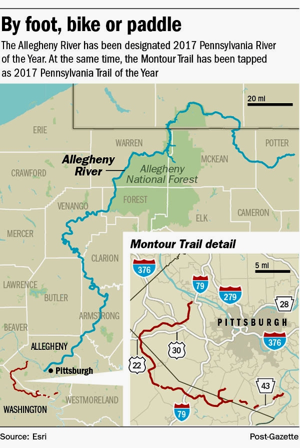
PG graphic: Trail and River of the Year
Many of those assets originated during the last North American Ice
Age. Glaciers separated the St. Lawrence River from its ancient
southern fork, reversing the flow southward to the Mississippi
River. Millennia later, the powerful Six Nations tribes and
Virginia militia Maj. George Washington considered that waterway
to be the mainstem and headwater of the Ohio River. But the Lenape
called it oo-lik-hannee, “the best river” (probably because it had
no canoe-tipping waterfalls), and the phrase was translated by
French explorers as “la belle riviere,” the beautiful river.
And that it is. From its origin as a Potter County creek, north
into New York then south to its confluence with the Monongahela
River, the Allegheny River flows some 325 miles past forests,
farmlands and industrial centers, comprising 60 percent of the
Ohio River’s source at Pittsburgh.
Historically relevant and at times controversial, the waterway
continues to be vital. French colonization of the long Allegheny
River Valley led to the first truly global conflict, known in the
U.S. as the French and Indian War. An important navigation
corridor, the river brought timber, coal and fuel oil to
industrial factories in Allegheny County.
As documented in the Johnny Cash cover of “As Long as the Grass
Shall Grow,” lands that were deeded in perpetuity to the Seneca
Nation were flooded during construction of the Kinzua Dam in
Warren County, but its long Allegheny Reservoir continues to
protect countless downriver towns from flooding.
Despite its industrial use, the river is respected for its
outstanding muskellunge, walleye and smallmouth bass fishing. In
1992 about 86 miles of the river, from Kinzua Dam to Emlenton in
Venango County, were federally designated a National Wild and
Scenic Recreation River. Seven of its islands fall under the
National Wilderness Preservation System, and in recent years
thousands of paddlers have learned what the Lenape knew — no
waterfalls, easy paddling..
The River of the Year honor focuses on the Allegheny’s Middle and
Upper sections. Penn Soil Resource Conservation and Development
Council, the group that submitted the application, will get a
$10,000 Leadership Grant from DCNR to help fund River of the
Year activities throughout 2017.
“It’s a beautiful experience,” said Fred Banter of Monroeville,
who with his wife, Julie Banter, paddled 20 miles of the Wild and
Scenic stretch last summer. “What I remember most is the quiet and
the slow pace of the river. We had a wonderful time.”
Ms. Dunn said, “People talk about how they go back in time on
the river. The forests, the mountains — It’s a high-quality
experience.”
About five miles west of the Allegheny River’s mouth, the Montour
Trail picks up the action where two old railroad lines left off.
Chosen Trail of the Year by DCNR’s Pennsylvania Trails Advisory
Committee, the designation spotlights a 63-mile rising star in the
state’s trail inventory.
“There’s a fantastic history along this stretch, and you can
really learn a lot whether you’re traveling quite a distance or
commuting to work,” said Ms. Dunn. “It’s a truly phenomenal trail
on a national level.”
Some 400,000 bikers, hikers, walkers, runners and cross-country
skiers take advantage of the trail each year. With a few remaining
gaps, its crushed limestone surface stretches from Coraopolis on
the Ohio River to Clairton on the Monongahela. It crosses the
Panhandle Trail near McDonald, includes several branches and
connectors including a bikeway to Pittsburgh International
Airport. It has a major linkup with the Great Allegheny Passage,
which stretches more than 330 miles from Pittsburgh to Washington,
D.C.
But for a pair of 12-year-old Bethel Park twins, the Montour Trail
offered a safe 1-mile off-road bicycle route to and from George
Washington Elementary School.
“It wasn’t that hard because it wasn’t that hilly,” said Naomi
Nass, who with her sister Charlotte now attends middle school.
“Sometimes we took umbrellas,” said Charlotte, “or we would walk
on the trail when it rained. There were a whole bunch of animals
— birds and bunnies and chipmunks and squirrels.”
Naomi’s greatest Montour Trail memory was walking backward and
accidentally stepping on a snake.
“Really long! Almost as wide as the trail,” she said. “We jumped
over it and ran really fast and screamed.”
Charlotte remembers selling marshmallowy Smokie cookies to trail
commuters for the all-volunteer Montour Trail Council.
“We raised $30 to help the trail,” she said.
Ms. Dunn said, “That’s so sweet. That’s the kind of story we hear.
People in the neighborhoods have really embraced this trail.”
John Hayes: 412-263-1991, jhayes@post-gazette.com.